


- Katie Taylor
- https://education.uw.edu/people/faculty/kht126
- Assistant Professor
- Mobile City Science: Youth Mapping Community Learning Opportunities
- https://www.education.uw.edu/mcs/
- University of Washington
- Elaina Boytor
- Learning Experience Researcher
- Mobile City Science: Youth Mapping Community Learning Opportunities
- https://www.education.uw.edu/mcs/
- Digital Youth Network, DePaul University
- Catherine Cramer
- Mobile City Science: Youth Mapping Community Learning Opportunities
- https://www.education.uw.edu/mcs/
- New York Hall of Science
- Tene Gray
- Mobile City Science: Youth Mapping Community Learning Opportunities
- https://www.education.uw.edu/mcs/
- Digital Youth Network
- Andres Henriquez
- VP STEM Learning in Communities
- Mobile City Science: Youth Mapping Community Learning Opportunities
- https://www.education.uw.edu/mcs/
- New York Hall of Science
- Remi Kalir
- http://www.remikalir.com
- Assistant Professor
- Mobile City Science: Youth Mapping Community Learning Opportunities
- https://www.education.uw.edu/mcs/
- University of Colorado Denver
- Caitlin Martin
- http://digitalyouthnetwork.org/staff/cailtlin-martin/
- Senior Researcher
- Mobile City Science: Youth Mapping Community Learning Opportunities
- https://www.education.uw.edu/mcs/
- Digital Youth Network, DePaul University
- Anthony Negron
- Mobile City Science: Youth Mapping Community Learning Opportunities
- https://www.education.uw.edu/mcs/
- New York Hall of Science
- Deborah Silvis
- Mobile City Science: Youth Mapping Community Learning Opportunities
- https://www.education.uw.edu/mcs/
- University of Washington


Public Discussion
Continue the discussion of this presentation on the Multiplex. Go to Multiplex
Jackie DeLisi
Research Scientist
What a great use of mobile technology to support the learning of both students and educators. Are the tools you have developed being used in just formal classrooms? Have they been tested in settings outside of the classroom?
Katie Taylor
Katie Taylor
Assistant Professor
Hi Jackie! Yes, we are using these activities with youth-serving programs, too!
Katie Taylor
Assistant Professor
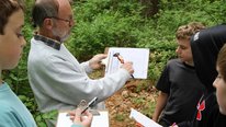
Hi Everyone. Thank you for checking-out our video. If you would like more information, please visit our website http://www.education.uw.edu/mcs/. Leave your thoughts and feedback here, too. Mobile City Science is a new project, with two implementations in Chicago and New York just completed and underway, respectively. Our aim is to provide young people with a systematic, digitally mediated inquiry process of de-coding their cities for building data-driven recommendations for urban change. To do this work, we rely on mobile, wearable, and geo-locative technologies and youth mobility within their neighborhoods and school communities. Youth are learning digital and spatial literacies that are increasingly important for participation in scientific disciplines and for understanding popular media. We are still refining a mobile tool that allows young people to not only engage in mobile mapping activities but also provide geo-located input that professionals can consider when developing plans for safe routes to schools, food accessibility, and placement of cultural and community amenities.
Deborah Silvis
Hi Jackie,
Thanks for this great question! The technologies and tools are really central to Mobile City Science and how young people engage in the project. For example, in a recent Historical Walking Tour of Corona Queens, high school students used Garmin GPS devices to track their pathways around Flushing Meadows Park and the surrounding neighborhood. This is a novel, local iteration of an MCS activity we call Historic Geocaching. Prior to embarking on their walk, they had identified maps of different eras and discussed how they showed different things about these places. By mobilizing the tools and technologies (literally, they took this learning activity and made it mobile!) they discussed on-site at locations like the park and a historic church how the neighborhood was continuing to change and what that meant from a youth perspective.
Katie Taylor
Adam Bell
Facilitating connections between young people and their neighborhoods is a meaningful and worthwhile endeavor for all who are involved in this project. And, Mobile City Science is a program that is continuing to expand. We're proud of the work being done across communities, and we're excited about the opportunities that lie ahead. Thanks to all the visitors who are taking the time to view our video.
Caitlin Martin
Katie Taylor
Wendy Martin
Hi Katie and colleagues!
I love this project and am happy to know it's in my neighborhood (Queens) as well at Seattle. I also think this video was very creatively produced--a great example of making the most of your medium. Deborah provides an example above of how this technology can be used for educational purposes, to teach about the history of an area. Are you or your NYSCI partners thinking of using this approach to help students use these experience to forward a real world interest or goal they have? For example, collecting data about a derelict lot so they could present a case to a local community board to get it cleaned up or turned into a garden or park?
Katie Taylor
Deborah Silvis
Hi Wendy,
Thank you for the positive feedback on our video production style! And fantastic that you are right in the neighborhood where MCS is running right now. If you are interested in seeing where the current cohort of MCS students lands as far as their locally-relevant problem and counter-map for addressing it, then you might want to attend their community meeting at NYSCI on June 7th. Stay tuned to our website for more details or feel free to contact us directly.
More broadly, yes, as Caitlin described in her post, developing a set of arguments for change based on youth's perspectives is a key component of the MCS program model. What we have seen so far across sites is that often what appears like an important problem to us (for example air quality in Queens associated with proximity to Laguardia airport) is not the salient issue for youth participants. Seeing the city from their point of view is critical because youth voices are not typically heard, despite the fact that young people are often highly motivated to enact change and are looking for entry points for civic engagement. Thanks for your great question!
Anthony Negron
Hi Wendy,
My name is Anthony Negron and I am the Manager of Digital Programming at The New York Hall of Science (NYSCI). We are currently working with a cohort of high school students that are using these tools and other ways of collecting data to explore their community. It is very exciting to see them be amaze in discovering assets in their community that they had never seen before and also question why certain assets don't exist in their neighborhood. Our students are currently developing their solutions and presentations to be made in front of their families and community panel in early June.
Katie Taylor
Caitlin Martin
Senior Researcher
Our team at the Digital Youth Network in Chicago facilitated the MCS project with a group of high school students in a south Chicago neighborhood. In learning about tools, collecting data, and walking their community, these kids came up with their own questions, challenges, issues they wanted to raise and discuss. For these ninth graders, the lack of available jobs for high schoolers was a theme they wanted to explore, as well as presenting what they cared about in a way that challenged existing narratives of where they live and go to school. Presentations to school and community representatives were really powerful.
Katie Taylor
Martin Storksdieck
Director and Professor
This is an interesting project. I have 2 questions: What is Mobile City Science (I know, I should Google it, but I thought you may want to frame it for us), and do you have evidence so far on how participation and engagement benefits the kids? Clearly they learn about their neighborhood, and they learn to do certain things, but are you aiming at some broader concepts? You mentioned digital and spatial literacies, but I wonder whether you could expand on that.
Katie Taylor
Katie Taylor
Assistant Professor
Thank you for the questions Martin! Here are some answers:
1. MCS is a community-based, digital STEAM curriculum for young people ages 13 - 19. Young people participate in MCS for six weeks or more and activities happen around their communities and within the classroom.We begin by posing this design challenge to participating youth:
Your neighborhood, like all neighborhoods, is changing. People are making plans about how it's going to change. Young people like you aren't yet part of the conversation. Let's change that!
Over the next six weeks, you're going to be using digital tools to learn more about your neighborhood so that you can make informed recommendations about how it should change. You will share these recommendations with people already making plans about your neighborhood.
The curriculum leverages mobile and geo-locative technologies (GPS, GIS, wearable cameras) to teach youth emerging digital literacies that are important for community engagement in an era of "smart cities." These digital literacies are:
2. Here is the evidence we have so far that participation in MCS benefits young people. Hopefully you will see some overlap in the teaching objectives we have, and others have been emergent (totally unexpected). Remember that we have just finished another implementation and one is underway, so we expect to see even more benefits after our analysis:
There's more to say, but I've run out of time ;) Thank you so much for the questions! Feel free to ask for clarifications if needed.
Further posting is closed as the showcase has ended.